


DECONFINEMENT

Jean-Paulchoux
User

Length
7.1 km

Max alt
665 m

Uphill gradient
236 m
Km-Effort
10.3 km

Min alt
465 m

Downhill gradient
241 m
Boucle
Yes
Creation date :
2020-10-11 07:40:52.638
Updated on :
2020-10-11 09:19:59.355
1h31
Difficulty : Easy

FREE GPS app for hiking
 SityTrail
IGN / Geographical institutes
SityTrail Plus
The world is yours!
About
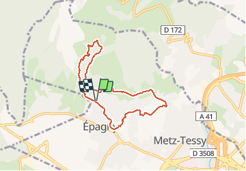
Trail Walking of 7.1 km to be discovered at Auvergne-Rhône-Alpes, Upper Savoy, Épagny Metz-Tessy. This trail is proposed by Jean-Paulchoux.
Positioning
Country:
France
Region :
Auvergne-Rhône-Alpes
Department/Province :
Upper Savoy
Municipality :
Épagny Metz-Tessy
Location:
Unknown
Start:(Dec)
Start:(UTM)
274047 ; 5092308 (32T) N.
Comments